MT 6

Plans changed a bit for our dive on the AJ Fuller.  We had Coast Guard clearance to be diving in the area, and we were in contact with them through the vessel traffic system (VTS), but when we got out near the target site there was an 800 foot long container ship anchored right over our planned area of operation.  We sat and waited for an hour or so for the ship to move out of our way and into its berth at Todds Shipyard – but then in an updated radio communication with VTS we learned we would need to wait for the container ship to move out of the way, and then wait for another to come & go before we could “commence our operation.”

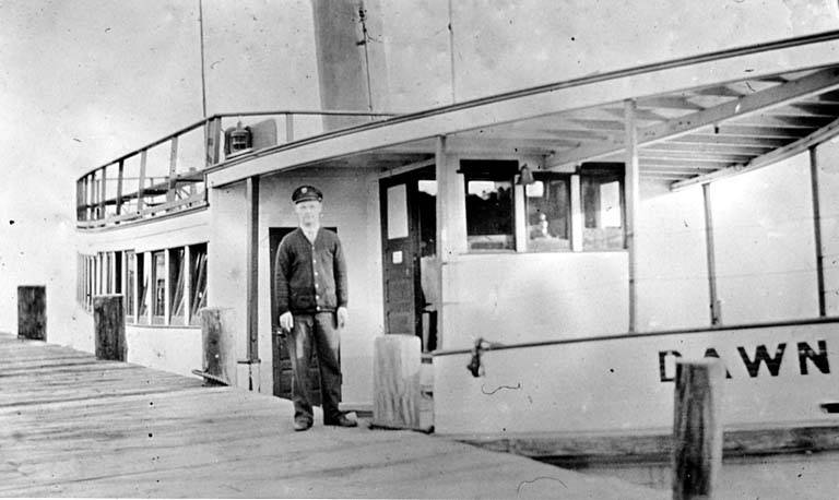
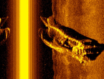
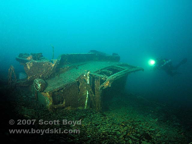
So we bailed on the AJ Fuller and moved from the East Channel entrance to the West Channel entrance for a dive on the M.T. No 6.  We don’t know a lot about the MT6, other than it was a train ferry converted to a barge and that it sunk on December 31st, 1949.  NOAA took a side scan of this one some years ago and the target location is visible on most NOAA maps of Elliot Bay.  It is also visible in the multi-beam image of Elliot Bay that I have posted on this website.

The depth of the wreck and our dive was 220ft.  We spent 25 minutes on the bottom, about 10 minutes getting up to our first gas switch and then 50 minutes in a stepped decompression to the surface.  Because of a tidal flow that occurs at depth on this wreck we brought scooters – and because of the depth and the time we would spend on the bottom we brought both 50% oxygen and pure oxygen for decompression gas.   

There was lots of life on the wreck, saw one ling cod that must have weighed 60 lbs.  We tied in to our drop line with a reel of cave line, and then ran a full loop around the wreck which turned out to be around 400ft (wreck is 150ft long by 50ft wide).  It’s a big wreck to see and by the end of our 25 minute dive we felt like we had just scratched the surface of it.

AJ Fuller

This Saturday I’m going out with the normal crew to make a dive on the AJ Fuller – a massive 229 foot long, three mast sailing ship that sunk in 1918.  She is sitting at the bottom of Elliot Bay, 240 feet deep, so I consider this dive to be a “big dive” if that makes sense. 

The AJ was owned primarily by Flint & Company of New York, and named for a shareholder who lived in Bath, Maine.   The three-skysail yard ship was one of a dozen ‘Down Easters’ built in 1881. Under the Flint house flag she sailed between New York, San Francisco, and Liverpool for ten years.

In 1892, she was put in trade from East Coast ports, where she loaded case oil for the ‘Orient’ or general cargo or coal to Hawaii, generally returning with sugar cane.  It was while she was in that trade that Felix Riesenberg, who later became a master mariner in his own right, sailed in her before the mast. 

She was sold to the California Shipping Company in 1902 and used in trade between the Pacific Northwest and Australia, exporting lumber and importing coal. In 1912, she was purchased by the Northwestern Fisheries Company of San Francisco, who employed her in their seasonal salmon fisheries—sailing north in the spring with fishermen, cannery workers, and supplies, and returning in the fall with a full load of canned salmon.

On October 18, 1918, while inward bound to Seattle in a heavy fog, she was rammed by the Japanese steamship Mexico Maru and sank in 240 feet of water.

aj-fuller1.jpg
(click to enlarge)

‘Potential New Wreck’ Now Located

Over the weekend I went out with 3 of my tech diving friends to search for the wreck mentioned below and we reprioritized the coal car exploration to another weekend.  We met early in the morning and loaded our friend’s small boat with four sets of doubles, 8 deco bottles and 4 sets of the ancillary gear that divers normally bring along. 

It was a short 1 mile trip from the dock, but when we got the boat on the coordinates for the expected target nothing was popping up like a wreck on the fish finder.  That is a predictable experience when your coordinates are converted from Loran C.  So we dropped a buoy in that location and began running circles around the buoy in an ever increasing radius type fashion.  The hope being that the coordinates are going to be within a few hundred feet of the actual target.  We spent a good twenty minutes running this search pattern and just about the time we were mentally thinking of other known targets we could dive (since we didn’t appear to be finding this wreck) a telling spike came up on the fish finder.  After running over that spot a few times to make sure we really had a wreck underneath we mutually agreed that it looked like a target in the range of 60-80 feet long with a 5-10 foot relief off the bottom.  So we repositioned our drop line on the wreck and prepared to make the dive.

Once we were all suited up and in the water we gear checked each other and then began the descent.  Almost immediately I had some ear issues; having a hard time relieving pressure in my right ear.  I fought this for awhile and almost gave up; but just as I was getting ready to let the other three go on without me, my ear cleared and enabled my decent to the wreck some 165 feet below the surface.  The visibility was great all the way down and stayed good on the bottom.  The four of us had the wreck illuminated really well with our HID lights and you could see the wreck out to distances of 20-25ft. 

The wreck was a burned out steamer, about 80 feet in length, with a narrow 9 foot beam.   Her charred hull was all that remained; with little clues as to her name.  You could tell she was painted white at one time, and that she had a big cabin deck very similar to passenger ferries like the Acme or LT Hass.  There is a strake all the way around her deck and some very basic framework still remaining. 

We spent 20 minutes on the wreck and about 25 minutes in a slow decompression ascent back to the surface using 50% oxygen from 70ft up.  With the viz being so good, we got some really good video of this one.  It’s going to be tough to identify this wreck with the limited clues; I’ll post an update here later if anything comes up as a potential candidate. 

Potential New Wreck & The Coal Cars

A few months ago when I was out conducting side scan sonar work with Innerspace Exploration, we hit an area North of 520 that had a number of wrecks within close range of one another.  

This area is generally known to the small group of local exploration divers, with the main wreck of the bunch being the YMS-359 – a US Navy Minesweeper that sits in 200ft of water and is about 135ft long.  So I didn’t think too much of the information until last week when I sat down with the data and tried to match wreck names to target locations.  As I matched coordinates to wrecks like Elfin, Urania, the previously mentioned YMS-359, Falcon, and Scout – I came up with one more set of coordinates than I had wreck names to match.

I bounced the general coordinates of this wreck off my friend Walter, who also has an extensive list of targets in the lake, and he couldn’t find a name to match either. So once again, I think we have a new target to explore…

The week of August 15th we’re going to make an exploration dive on the Coal Cars.  I have wanted to hit these submerged targets for awhile, so we’re going to make a dive on them first.  They are right up next to the 520 bridge, which can be really rough water depending on the wind conditions. 

Post dive we’ll head to the new coordinates to confirm them one more time; and see if we can locate the wreck with a basic fish finder. If we confirm the position of the wreck, we’ll make a dive on it a short time later. 

LCVP & The Dawn

Over the weekend we made the initial dives on the landing craft; we had 7 divers total including myself. Two of the divers were armed with video cameras so we shot lots of above and under water video – should make for a good DVD compilation. 

The landing craft is generally intact and it is sitting upright on the bottom with the ramp down. It appears it was scuttled on purpose rather than by accident, with a few long purposeful gashes in its side and most of the equipment removed.  Normally the LCVP would be armed with 30cal machine guns, but they were missing (only the empty turrets remain – one of them on the floor of Lake Washington next to the wreck).

If you view  the schematic in the prior entry (below) you can see what I am talking about. Fuel tanks, towing pad, ramp latch, etc.  These are the type of items that remain.  We did manage to get numbers off the wreck and are now in the process of researching them: “PA 52-22.”  If you know landing craft or have the ability to search their history I would appreciate the help with this one.

[]

After the exploration of the landing craft we moved over to a favorite of mine, the ferry boat Dawn. This wreck also sits upright on the bottom of the lake and is generally in good shape.  It’s a spooky wreck compared to the landing craft, because you can go inside.  If you click on the photo of the Dawn that I’ve included below you can see it’s big square windows.  Imagine being deep in Lake Washington and swimming through one of those windows, the heavy steel tanks on your back barely fitting through, scraping the sides of the window as you slither in.  Now you are inside and you can see only what your light shows you in a focused beam.  It is a disconcerting feeling to know there is ceiling above you but you can’t see it unless you point your light straight up.  We entered through a window near the stern and exited out a breezeway door at the bow.  Shot some great video of this wreck as well.

dawn1.jpg
(click to enlarge; photo courtesy of UW Digital Collections)

Navy Landing Craft

Got a chance to get out on the lake this past weekend with Innerspace and we picked up a scan of what we believe is a Navy landing craft.    

36ft long, 11ft wide. Depth on this one is only about 90ft.

The wave in the side scan towards the front of the boat is caused by surface waves. It was kind of choppy out there with a significant amount of boat traffic.

The other attached images are historical photos for context.

Should be fun to get out on this one; see if we can get numbers and research its history.

Probably dive it this Saturday.

landing-craft.jpg
(click to enlarge)

landing-craft-blueprint.gif
(click to enlarge)

lcvp.jpg
(click to enlarge)

omaha_landing_craft.jpg
(click to enlarge)

Warren’s 1927 Chevy

On Saturday I made a trip up to Lake Crescent, Port Angles in the Olympic National Park with friends Peo and Steve C.  The objective was to make a dive on the famous Warren car wreck.  Just a handful of divers have had the chance to make this dive so it was an exciting opportunity.The story behind the wreck is filled with traumatic outcomes and mystery: July 1929 Russell Warren left his 12 and 14yr old sons with $35, paid off a $100 grocery tab, picked up a new washing machine and then left to go pick up his wife, Blanch, from the hospital.  On their return they simply vanished; leaving two sons and a community wondering what had happened to them. 

Over the years the boys heard rumors that their parents had run off; Blanch’s father had also disappeared years earlier, never to be heard from again.  So there was a certain mystique surrounding this family.  In 1929, $35 seems like an awful lot to leave with the kids.  Why pay off the grocery tab that same day?  Was it simply a matter of money on hand or was it a man tying up loose ends?  But if it was planned; why buy the washing machine?  The two boys lived their life always wondering what happened, and they never found out – both boys died as men in unrelated events before the car was located or the mystery solved.  The car, along with some remains, was finally found in 2001 with the use of side scan sonar and volunteer technical divers.

Once we were armed with the general location, Peo, Steve and I had heard that we would be able to see the wreck once we approached a depth of 170ft; this made us incorrectly assume we would find the wreck closer to 180ft deep.  As such we traveled with 18/45 (oxygen/helium) as back gas.  The slope was incredibly steep; an angle that matched the water temperature: 45degrees.  The water was a perfect blue/green color that reminded me of the tropics; same with the visibility which approached 80feet.  So we dropped down to a depth of 180ft and began following the contour line towards the direction of where we were supposed to find the wreck.  12 minutes of swimming at that depth later, we finally could see the wreck’s shadow some 60ft in front of us.  We found it at a depth shallower than we had been traveling, in 166ft of water.

It is lying on its side on the steep slope; and to me it looks like it has rolled down to this position over the years; there is lots of loose rock and shale in the area – and it has the wreck partially buried.  I tentatively reached out and touched the frame of the car, partially expecting to ‘feel’ something ghostly.  I didn’t, but something more than respect kept me from touching the wreck again. 

Among the myriad of rocks and boulders in the area, I noticed a large stone in close proximity to the Chevy that had a clean hole drilled into it like those you would expect to see in rock that had been drilled for dynamite.  My personal theory is that the wreck was at one time in a shallower position but as they blasted rock to improve and widen highway 101 they inadvertently pushed the wreck to its current depth and partially buried it at the same time.  There are even rocks in a the wheel well that is closest and parallel to the surface; a condition I would expect to happen only if the rocks came from above or if the wheel well scooped them up as it rolled down the hill.        

After a short survey of the wreck and the surrounding area we hit our 20minute bottom time; the limit we had set for ourselves in pre-dive planning.  So we began our slow ascent and decompression back to the surface.  By the 60minute mark we were back on the surface, breathing natural air and talking about the dive – mainly kicking ourselves for not bringing photo or video equipment.  As such… we’ll be back. 

slb_0006.jpg

Back on the Lake

This past weekend I was back out with Innerspace; searching for unfound wrecks in Lake Washington.  We were on the water running side scan for pretty close to 8 hours straight on Sunday; looking hard for two bi-plane seaplanes that crashed in the 1920’s south of the 520 bridge.  We found a couple targets in the right area but on close review they don’t appear to be airplane parts.  We’re planning to go back and make a quick dive on one of the targets just to be sure it isn’t a wing.  During the day we did manage to pick up good scans of a few known boat and shipwrecks in the area: SL Dowell, YMS-359, The Bremerton and a burned out hull – but never came across the plane(s) we were looking for.

Alki Plains Line Project

The last month and a half I’ve been diving with the aplponline.org group making extended range dives on DPV’s (diver propulsion vehicles), a.k.a. ‘scooters’. 
Starting at Seacrest Cove 2 (off Alki) we have more than 7000ft of cave line run at an average depth of 110ft.  The round trip is nearly 3miles.  Pretty incredible dive to make/distance to cover at that depth.  

The goal has been to get proficient at laying cave/wreck line while running scooters, repairing & working with loose line (dealing with entanglement hazards, etc), improving communication and line protocol and active training for bigger/deeper dives.

The last dive I made out there we had a great encounter with two harbor seals.  They were being so friendly and curious… checking us out and brushing up against the scooters – it honestly looked like they thought the scooters were other seals.  After disappearing for awhile, one seal came up behind me and nipped one of my fins – which gave me an adrenaline jolt based on the number of shark encounters we experience in this area as well.   

It’s been fun; but I am anxious to get back out in the lake to see and possibly find more historical wrecks.  More on those efforts to come…
  

Avenger Documentation

Spent most of the weekend on or in the lake, working on tying together and documenting the Avenger.

Saturday morning the team of Kurt, Miranda, Walter & Mark dove with the objective of connecting the dots (I played boat driver for this one). We had previously connected the main section of fuselage to the tail (about 30 feet away) with cave line. We had a bearing and distance (85 feet) to the starboard wing, lying on the bottom. From the starboard wing, we had another bearing and distance (about 50 ft.) to two four foot sections of wreckage (status unknown). They dropped on the fuselage, tied in and ran out 90 ft. of line. Spaced themselves out on the line and swam a quick search pattern to locate the wing. Once on the wing, they repeated the process to locate the two other pieces of wreckage. It took about 25 minutes for them to locate and connect the pieces and they incurred about 30minutes of deco. So just about an hour long dive all together with a max and average bottom depth of 175ft.

Sunday morning, the team of myself, Rich, Walter & Mark returned to the site with the video camera. With all the pieces connected together we were ready to finish documenting the site. We spent a leisure 30 minutes on the bottom enjoying the site; making sure we documented everything. Once edited we’ll publish a copy of the video to the Naval Archives/Historical branch for their records.

KUOW Radio

Spoke with KUOW yesterday about diving in the lake:

Audio can be found here: http://www.kuow.org/program.php?id=12041

Diving in Lake Washington
John Sharps is a diver who has discovered old ferry boats, World War II aircraft and all manner of objects on the bottom of Lake Washington. He joins us to talk about his passion for diving and Pacific Northwest history as preserved in depths of up to 200 feet.

Related Links:

PV-2 Harpoon & USRC Scout

Made a couple dives in the lake on Sunday…

The first dive was on the PV-2 Harpoon – a World War II patrol bomber that was ditched after take-off in Sept 1947. It’s a great dive, the plane is stuck nose down in the mud and the tail is broken off so there is opportunity to drop down inside. 50 caliber machine guns still in the turret. Max depth was about 145ft.

The second dive was much shallower but more historic. Back when we were looking for the Avenger we found via side scan the hull of a 60ft ship lying on its side in relatively shallow water (90ft). So our second dive was on this wreck and it turned out to be a great one. 5 of us made the dive. The three man team I was on shot video and took a bow to stern measurement. The second two man team took beam and draft measurements. On the bow of the ship you can still just barely read what we collectively thought was the name, ‘SCOUT.’

Researching vessels by that name later that evening and comparing notes to our length and beam measurements we were able to match Scout to an early 1900’s era Coast Guard Revenue Cutter. One of the first that was gasoline powered. It was based in Port Townsend, WA where its primary purposes were to thwart illegal immigration and opium trade. In 1915 it was transferred via private sale to Puget Sound. Other than that the rest of its history above water remains a mystery.

GUE Tech II

I spent the holiday week taking tech2 with Andrew Georgitsis of GUE and 5th D-X.  I made it through the class successfully but I’ll tell you it was a grueling week – both emotionally and physically.  I intended to post a daily blog on the class but that proved too difficult with both class activities and the pending holiday.  Our check-out dive was on the YMS-359 (Minesweeper) in Lake Washington.  Depth is/was 200ft.

Eyewitness Account

We got a great e-mail from an eyewitness to the Avenger crash today. He was a 12yr old passenger on a sailboat the day of the accident. Here is his account as he remembers it today:

—– Original Message —–

From: Paul Moran

Sent: Friday, December 03, 2004 8:29 PM
Subject: TBF Crash 8/17/42
The recent articles that have appeared in the Times about the Lake Washington crash of an Avenger have brought back some long ago memories for me. I was on a 40′ sailboat near the crash site when it occurred. We had been to a marina in Houghton and were returning toward moorage between Juanita and Champagne Point. Someone aboard shouted “look at that plane!” and when I looked it was approaching the water at high speed and at a fairly steep angle. When it hit, the wings appeared to fold forward and all kinds of debris threw up spray ahead of it. A large piece of debris which we thought was the propellor cartwheeled across the water ahead of the fuselage. We saw what we thought to be the pilot thrown 20 to 30 feet into the air and doubted that he would survive.
We turned the boat around and proceeded to the crash site to see if there were any survivors. We found a person floating in his life jacket who was dazed and barely conscious. We could see another person also floating in the water some distance away that seemed to be in slightly better shape so we stayed with the first person to be sure he wouldn’t drown. We were afraid to bring him aboard because we didn’t know the extent of his injuries. We held him along side until a crash boat arrived from Sand Point which retrieved both persons.
We saw in the paper that the radioman did not survive and suspected he may have been manning the belly or ball turret.
The navy sent a Mary Ann class powered barge with a crane on it and spent quite some time trying to retrieve the plane. I don’t recall if they recovered the body or not. That might explain why the debris is so scattered.

I also witnessed another TBF crash north of Sand Point during the Sammamish River hydroplane races one year. The plane flew up about as high as the hill on the West side of Lake Washington when it lost power and glided down to a gentle landing on the water. The pilot got out on the wing and looked like he was trying to figure out how fast the plane would sink when a small hydroplane came by near us so we waved our arms and pointed at the plane. The racer left the race and went over to the plane where the pilot stepped off the wing onto the hydroplane and didn’t even get wet.
That TBF may have been retrieved although I seem to recall the paper saying it was in something like 371 feet of water.
Another crash that I knew about involved my next door neighbor. He was commander of Quillayute Naval Air Station near Forks,WA. He frequently commuted to there by light plane (usually a Beechcraft staggerwing). He lost power in the vicinity of St. Edwards Seminary and Kenmore and crashed into the Lake. They had trouble getting out of the plane but were not injured. The passenger was on his first flight and swore he would not do it again. I don’t know if the plane was recovered or not but I suspect it was.
Just thought you might be interested.
Paul Moran

The Dives Today

Successful dive on the Avenger today; got out on the tail section for the first time. The tail is standing upright, horizontal stabilizers are about 16ft across.

With three main portions of the wreck; the main fuselage (that includes one wing), the tail section and then the other wing sitting some 85ft away – it appears a portion of the tail fuselage is missing. This would have been the section where the ventral gunner sat. Since he died during the accident (went down with the plane) it is possible the Navy recovered that portion of the craft, including his body, back in August of 1942.