Link to SS Governor history and underwater images:
http://www.scret.org/index.php?option=com_content&task=view&id=33
Multibeam imagery of the ship included below:


Link to SS Governor history and underwater images:
http://www.scret.org/index.php?option=com_content&task=view&id=33
Multibeam imagery of the ship included below:
")
Excerpt from Baldt Anchor & Chain; included here as evidence the Chatham may have carried cast malleable chains for use with its stream anchor.� HMS Chatham was only 80 feet long, but nearly 140 tons which is to say she was damn heavy.� The use of chain presents itself as appropriate for a ship this weight.
[From the time of Caesar until the the 13th Century we find little or no mention of the use of anchor chains. Between 1200 and 1700 A.D. we read that iron cables are sometimes used. The statutes of Genoa of 1444 make brief mention of “iron anchor chains.” An engraving of 1512 shows a ship with hawse holes and anchor chains clearly depicted.
Again a lapse until in 1634 Philip White patented in England “A WAY FOR THE MEANING OF SHIPS WITH IYRON FOR THAT PURPOSE AND THAT EH HATH NOW ATTAYNED TO THE TRUE USE OF THE SAID CHAYNES AND THAT THE SAME WILBE FOR THE GREAT SAVEING OF CORDAGE AND SAFETY OF SHIPPES AND WILL REDOUND TO THE GOOD OF OUR COMMON WEALTH.”
In the ensuring half century a few far sighted ship owners and ship captains had sufficient faith to experiment with iron chain, for in 1771 the French explorer Brouganville complained that he had lost six anchors in nine days and narrowly escaped shipwreck, which would not have happened had his ship been fitted with iron chains.
In 1778, General George Washington conceived the idea of a buoyed barrier chain across the Hudson River, at West Point, N.Y. as a means of impeding the invading British fleet. In six weeks seventeen American blacksmiths forged a 1700 ft. long chain of 3-1/2 inch square stock weighing 275 pounds per link. This chain is still preserved at the US Military Academy, West Point. N.Y.
In 1783 George Matthews, of England, 150 years ahead of his time made cast malleable chains for ships. It was not until World War I that cast steel chains were fully developed.]
Source: Baldt Anchor & Chain (Chester, PA)
Repost of Content Compiled by Underwater Admiralty Sciences:
Original Content Located Here: http://www.nwrain.com/~newtsuit/uas/vancouver.html
Chatham’s Anchor:
It is always a matter of chaos and immediate action when a vessel loses its anchor. It borders on catastrophic when the vessel is thousands of miles from its homeport and is carrying no spare. This unwelcome circumstance assailed the Chatham, one of the two vessels of the Vancouver expeditions in the cold and deep waters off the San Juan Islands. That anchor, lost two hundred and ten years ago, almost certainly lies now where it was lost. Additionally it is the only empirical proof of Vancouver’s exploration and British claims in the Northwest.
To explain the circumstances for the loss of the anchor we begin with the departure of the HMS Chatham in England…
As loved one’s waved goodbyes and government officials eagerly encouraged the departure to grab lands in the New World, the Chatham left England on April 1st, 1791, as the Armed Tender to the HMS Discovery, the flagship of Captain George Vancouver. Both vessels were bound for the Northwest coast of America. In April 17, 1792 they reached soundings off the Cape of Mendocino in Northern California. Traveling north they would venture in close (but not too close as too close was often an invitation to disaster) to shore to explore, sound, map and observe the local fauna and topography. At night they would stand out to sea for safety. Safety from the tides, reefs, rocks and unfriendly locals. On April 29th they entered the Straits of Juan de Fuca. A few days later, at the suggestion of Lt. William Broughton, commanding officer of the Chatham, they anchored in a very large bay. Calm waters and an abundance of fresh water and game beckoned them to the first anchorage for the expedition and was named Port Discovery after the expedition’s flagship. It was later changed to Discovery Bay.
According to logs, for the next two weeks, Vancouver used this calm bay as a base from which he and his men, in open boats, explored the upper waters of what is now Admiralty Inlet as well as the total waterway of Hood Canal.
On May 18th Vancouver personally explored the large hill on Protection Island, which sits astride of the opening to Discovery Bay. From the summit of Protection Island one could see many islands – the San Juan Islands – to the northeast. Vancouver directed Lieutenant William Broughton, the commanding officer of the Chatham, to explore those islands while he and the Discovery explored the waters to the south.
Broughton set out on that reconnaissance on May 18th, 1792. He returned to the Discovery anchorage between Blake and Bainbridge Island on May 25th, 1792Vancouver made in his journal one brief entry mentioning Broughton’s exploration:
“Mr. Broughton informed me, that the part of the coast he has been directed to explore, consisted of an archipelago of islands lying before an extensive arm of a sea stretching in a variety of branches between the N.W. north, and N.N.E.”
Vancouver’s sparse entry leads one to believe that Lt. Broughton had accomplished little during his week of exploration. Fortunately, however, Lt. Broughton’s hand-written report of his exploration of those islands, (known today as the San Juan’s) is preserve and now located in the British Nautical Museum. The report reveals that the men of the Chatham were far from idle.
The existence of Lt. Broughton’s manuscripts has long been known. It was one reprinted by the Washington Historical Quarterly under the title; “Broughton’s log of a Reconnaissance of the San Juan Islands 1792.”
The British Hydrographic Office – in England – archives materials from the Vancouver expedition. Of particular interest is a hand-drawn chart by Lt. Broughton with only two places named, “Birch bay” and another Bay.” The first glance at the chart is puzzling; its features look completely unfamiliar. But, when you lay the hand drawn chart next to a modern navigational chart of the American San Juan Islands the similarity is immediate. Only a handful of the rough charts of the Vancouver expedition have survived to the present day. It was argued that without a doubt, the chart of Lt. Broughton was the first chart of the San Juan Islands, however scholars since have noted that Francisco Eliza and crew, aboard the San Carlos, a Spanish Brig, did the “first chart” of the San Juan’s the year before in 1791. Juan Carrasco was the mapmaker.
With the chart, and in conjunction with Broughton’s written accounts, one can easily reconstruct the course of the Chatham as it maneuvered through the tricky and unknown current and waterways of the San Juan Islands. After leaving Discovery Bay, the Chatham sailed almost North across the Straits of Juan de Fuca. On that passage Broughton observed the opening between San Juan and Lopez Islands and set his course for the southern gateway into the islands. Sending a small boat ahead to sound the waters of that turbulent and threatening passage, Broughton proceed with caution through Cattle Pass and into the broad expanse of water between San Juan and Lopez Islands. Using a dash line to mark his progress (as on the original handwritten chart of Broughton) the Chatham passed through Cattle Pass at the lower left side. Late that day Broughton sailed the Chatham in the Upright Channel between Shaw and Lopez Islands, anchoring at night off of Lopez Island.
The next day Broughton sent out two long boats under the command of James Johnstone, master of the Chatham, to explore the northern area Johnstone charted what we now know today as Waldron, Skipjack, Spieden, Johns and South Pender Islands.
The next day the tireless Johnstone returned in the Chatham’s cutter to Cattle Pass to sketch the entrance through which the two vessels had passed between Lopez and San Juan islands. At the same time there was no wind, so Lt Broughton ordered that the two long boats tow the Chatham toward the opening between Orcas and Blakely Islands.
On the 21st the Chatham worked her way through Peavine Pass into Rosario Straits and on the following day Broughton sailed the Chatham across Rosario Straits to a protected cove.
All during this time the Chatham was among the islands, Lt. Broughton had been sending out exploring in all directions. By the 23rd of May 1792 he felt he had carried out his mission for on that date he sailed southward to rejoin Vancouver and continue the explorations of the water south of the Strait of Juan de Fuca.
After completing their explorations south making it as far as Commencement Bay in Tacoma, both ships headed north for the safety. The southern portion of Puget Sound was susceptible to SSE storms with abundance of severe currents and tides. It was during the northbound trip when the Chatham suffered the loss of her stream anchor.
The wind had failed and as the Chatham was crossing an unknown channel when, she was caught by the flood tide and swept helpless, to the northeastward. To slow her progress in the waters of unknown depth the stream anchor was dropped. When the vessel was brought to, the strain was too much and the cable parted. Moments later the Chatham let go of her bower and the vessel was stopped before potential disaster occurred.
This was a serious moment the potential for disaster was noted in the journal entry by Edward Bell, the young clerk of the Chatham:
“We found the tide here extremely rapid and endeavoring to get around a point to a bay in which the Discovery had anchor’d, we were swept to leeward of it with great impetuosity. We therefore let go the Stream anchor, but in bringing up, such was the force of the tide that we parted the cable. We immediately let go with the Bower with which we brought up. On trying the tide we found it to be running at a rate of 5 � miles an hour. At slack water we swept for the other anchor but could not get it, after several fruitless attempts to get it we were at last obliged to leave it and join the Discovery.”
And Archibald Menzies, the naturalist of the expedition, made the following journal entry:
” — the Discovery with the assistance of her boats was able to get into the East side of the opening near the entrance where she came to an anchor at 6:00 in the evening, while the Chatham was impelled by strong flood tides into an opening a little more to the eastward, in which situation as neither helm nor canvass has any power over her, all were alarmed for her safety and anxious to hear of her fate.”
On the following day Menzies journal stated:
“Next day a Boat came to us from the Chatham when we were informed that she was at an anchor in a critical situation at the entrance of an opening eastwards of us where they lost their stream anchor by the force and rapidity of the tide which ran at a rate of about five miles an hour and snapped the cable as they were bringing up, as often as the tide slackened they used their endeavors by every scheme they could think of to recover the lost anchor, but without success and the loss of it was more severely felt as is was the only one of the kind they has been supplied with.”
| The ship carried other more laborious anchors but quite often the stream anchor was the anchor of choice after a long day in unknown waters – such luxury would be sorely missed.
It is regretful that better land references were not made of the lost anchor’s position but at the moment the critical nature and safety of the Chatham took priority. I am sure that none of the officers or crew would have ever imagined that 210 years later individuals would be reviewing their journals in an effort to locate the lost anchor. The events and journals are the proof that Vancouver’s expedition vessel Chatham lost an anchor. Charts today can be examined and with relative ease the above information and actions can be tracked. The information recorded in the journals give us critical clues as to the location of the lost anchor. Today technology, specifically a “Proton magnetometer”, can locate this anchor given the mass and the nature of the ferrous metal, in any bottom composition. Facts indicate – after trips to the site – that the bottom is rocky. More likely than not, the anchor became lodged in rocks and when tensions was taken up by the Chatham’s movement in the current the mass of the ship proved to be too much for the wedged anchor and cable to hold. The cable parted and the anchor remains on the bottom. The renowned shipwreck archaeologist Jim Delgato estimates the anchor’s size somewhere between 6 to 9 feet in length – a square shank and weighing around 700 to 900 pounds. The fluke tip to tip is approximately 3 feet and the stock was made of English Oak, most likely, the marine wood boring organisms has consumed the stock. For [218] years the only known artifact to have been left by Vancouver’s expedition is the lost Chatham Anchor. Its location and recovery will stir international interest and a legal battle over ownership. In the end, the Anchor will be preserved and be a modern reminder that we can capture moments from the past and allow them to be enjoyed by all. |
Annotated “Chart Shewing Part of the Coast of NW America with the Tracks of His Majesty�s Sloop Discovery and the Armed Tender Chatham” – From Vancouver’s Voyage by James Stirrat Marshall

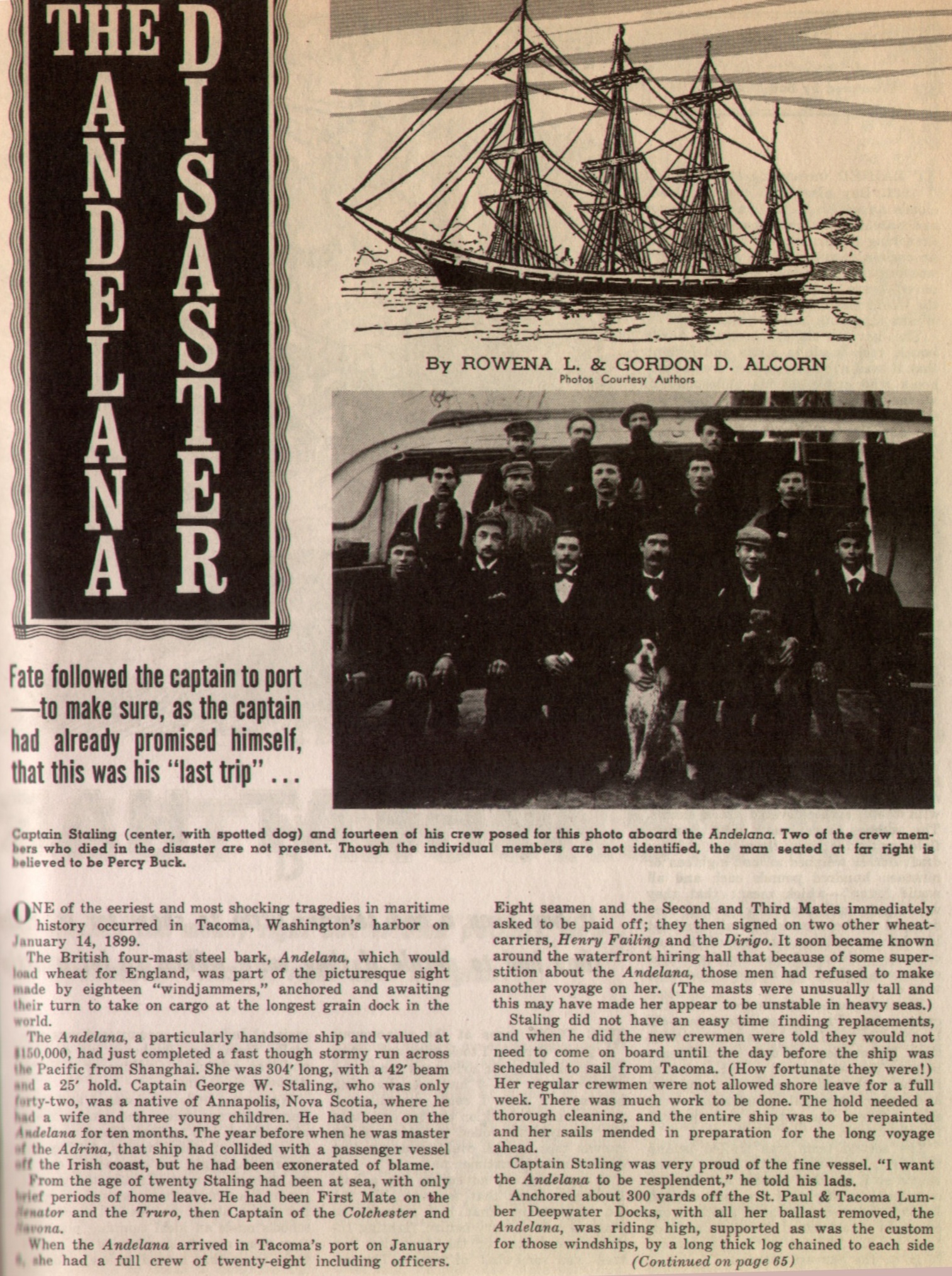
Published January 1899:
(click each to enlarge)
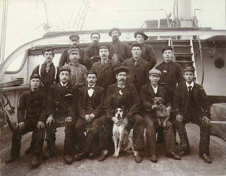
This is a photo of the crew, literally taken the day before the accident. No one in this photo survived.
(click to enlarge)
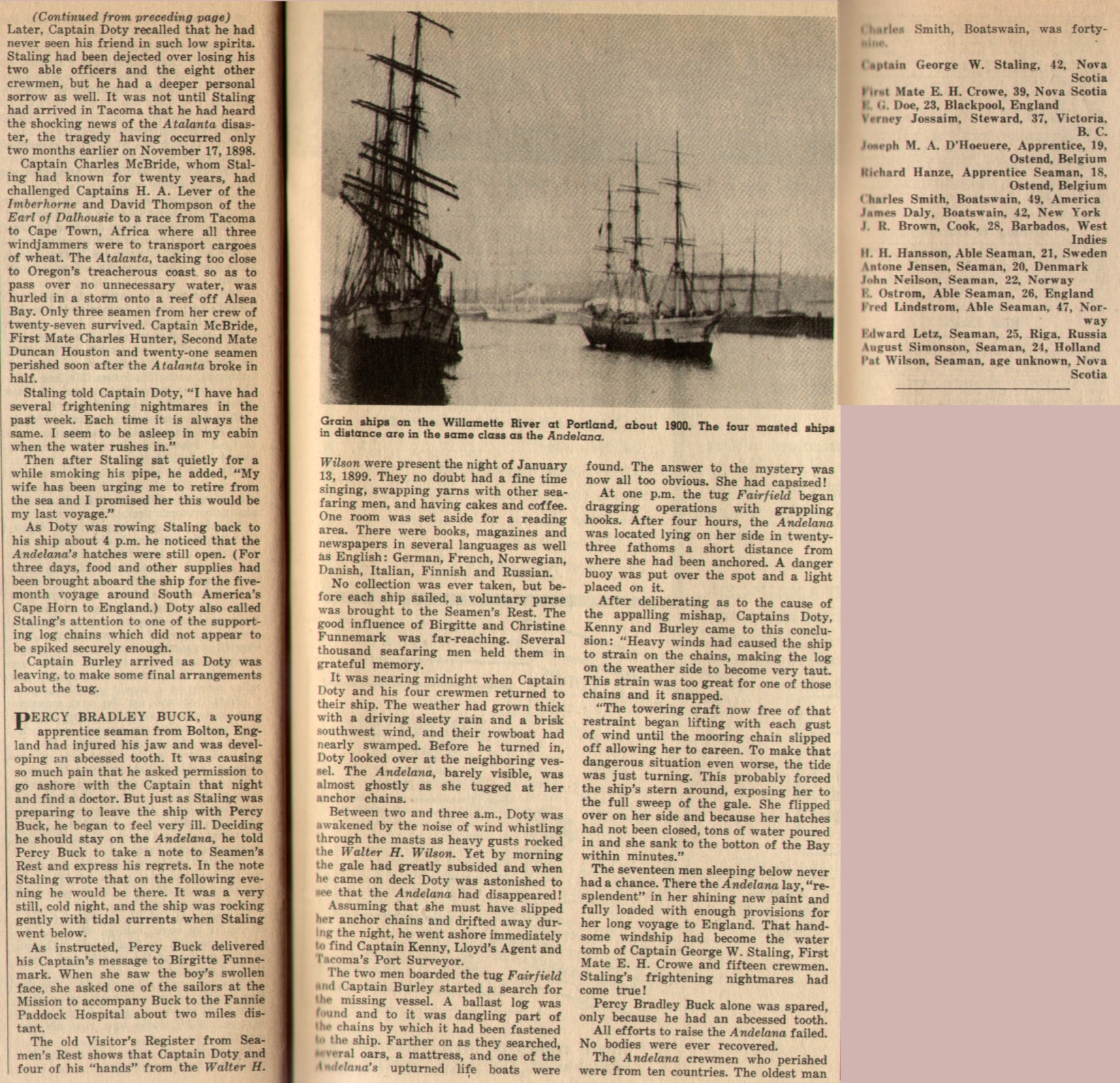
Names of those men lost:
BROWN, J. R.
CROW, E. H., First Mate
D’HOEUERE, Joseph M. A., Apprentice
DALY, James, Boatswain
DOE, E. G.
HANSON, H. H., Able Seamen
HANZE, Richard, Apprentice
JENSEN, Antone, Seamen
JOSSAIM, Verney, Steward
LINDSTROM, Fred
LUTZ, Edward
NIELSON, John
OSTROM, E.
SIMONSON, August
SMITH, Charles, Boatswain
STALING, George W., Captain
WILSON, Pat
A four-masted steel barque built in 1889 by Richard Williamson & Son, Workington.
Rigged with royal sails over single topgallant and double topsails.
The lower and topmasts were made in one piece.
Belonged to the group of six four-masted barques called the Workington Sisters consisting of Eusemere (1890), Pendragon Castle (1891), Vortigern (1891) Caradoc (1892) and Conishead (1892).
Sailing History:
1889 October
Launched at the shipyard of Richard Williamson & Son, Workington, for the Andelana Ship Co. (E.F. & W. Roberts), Liverpool. Assigned the Official British Reg.
Captain J. Gillis was given command of the ship.
1889
Sailed on her maiden journey from Barry to Table Bay in 51 days with a cargo of coal.
1890
Sailed from Table Bay to Calcutta in 54 days in ballast.
1890
Sailed from Calcutta to New York in 112 days with a cargo of jute.
1891
Sailed from New York to Shanghai in 144 days with a cargo of case oil.
1891
Sailed from Shanghai to San Francisco in 32 days in ballast.
1891
Sailed from Hong Kong to San Francisco in 31 days.
1891
Sailed from San Francisco to Queenstown in 107 days with a cargo of grain for Hull.
1892-1894
In command of Captain J. Richards.
1892
Sailed from Hull to New York in 42 days in ballast.
1892 May 10 – August 20
Sailed from New York to Shanghai in 111 days with a cargo of case oil.
1892
Sailed from Shanghai to Kuchinotzi in ballast.
1892
Sailed from Kuchinotzi to San Francisco with a cargo of coal.
1893 February 20
Sailed from San Francisco to Liverpool in 93 days with a general cargo. Was off Brow Head 88 days out but had to put into Holyhead to wait for a sufficient tide to get to Liverpool.
1893
Sailed from Liverpool to New York in 24 days in ballast.
1893/94
Sailed from New York to Hong Kong in 140 days with a cargo of case oil.
1894
Sailed from Hong Kong to Iloilo in 9 days in ballast.
1894
Sailed from Iloilo with a cargo of sugar for Delaware but had to touch at St Helena 120 days out for water and provisions. Arrived at Delaware 44 days later.
1894
Sailed from Delaware to Halifax in 9 days.
1894
Sailed from Halifax to New York in 11 days in ballast.
1895-1899
In command of Captain George W. Stailing late of the same owner’s ship Andrina which had been damaged in a collision with a steam ship.
1895
Sailed from New York to Yokohama in 130 days with a cargo of case oil.
1895/96
Sailed from Hiogo to New York in 185 days.
1896
Sailed from New York to Yokohama in 119 days with a cargo of case oil.
1896 October 1 – October 24
Sailed from Yokohama to San Francisco in 23 days in ballast.
1896/1897
Sailed from San Francisco to Sydney in 45 days in ballast.
1897
Sailed from Sydney to San Francisco in 63 days with a cargo of coal.
1897
Sailed from San Francisco to Queenstown in 116 days with a cargo of grain for Antwerp.
1898
Sailed from Antwerp for New York with a cargo of cement. Received storm damage to the rigging and had to put into Queenstown 30 days out. Subsequently sailed to Liverpool for repairs.
1898
Sailed from Liverpool to New York in 24 days.
1898
Sailed from New York to Shanghai in 133 days with a cargo of case oil. Was dismasted in a typhoon and had to be repaired at Shanghai.
1898 November 21 – January 6
Sailed from Shanghai to Port Angeles, WA, in 47 days in ballast.
1899 January 14
While at anchor in ballast at Tacoma, Puget Sound, WA, the chains to the ballast logs broke at a sudden squall during the night and ship capsized and sank. The master and the crew were all killed when the ship went down.
From the New York Times, 15th January 1899
“17 MEN DROWNED IN PORT”
“British Bark Andelina sinks at Tacoma, Washington.”
“Little Warning to the Crew.”
“Ship careens and goes down, giving the sailors on board no chance to escape.”
TACOMA, Washington, Jan.14.
The British bark Andelina, 2,345 tons, of Nova Scotia, Capt.G.W.Stailing, sank in 22 fathoms of water in front of the St.Paul Mill wharf, and the Captain, the mate, and fifteen of the crew were drowned. The accident occurred during the night.
The vessel came four days ago in ballast from Shanghai. The ballast had been discharged, and the ship was lying at anchor waiting to be towed into the dock. Last night a terrific gale raged out in the bay, the wind blowing thirty-six miles an hour. Two great boom logs were placed beside the Andelina, one on each side. During the gale between 2 and 4 this morning one of the logs went adrift, causing the ship to careen and to capsize with very little warning to the crew. The vessel was entirely without ballast and the hatches were open. All on board were caught like rats in a trap and had no chance of escape. The ship simply careened over, the water flowed in the open hatches, and she sank.
At daylight this morning the ship was missed. Where she had been riding, apparently securely at dusk the night before, there showed but a blank stretch of water. The wreckage which was strewn about the bay told the vessel’s fate. A large number of the crew were discharged yesterday, or the loss of life would have been far more appalling. The ship was to commence taking on a cargo of wheat for Queenstown today, and was to receive further orders. Capt.Stailing lived in Anapolis, N.S., and leaves a widow and three children. He is well known in this port.
The Andelina left New York May 9 last for Shanghai, carrying case oil, and arrived there Oct.19. She reached this port less than a week ago, to load wheat for Eppinger & Co., San Francisco, for export to England. She was built at Workington, North England, in 1889, and was owned by E.F.& W. Roberts of Liverpool, and was rated A1 by Lloyds. Her dimensions were : Length, 330 feet; beam, 42 feet; depth of hold 24 feet 6 inches; tonnage, 2,395 net. ”
On January 14 [1899] a tragic accident had occured in the harbor of Tacoma. In contrast to the freightening uproar attending the Kingston-Glenogle collision, this disaster took place without warning and in almost complete silence.
The four-masted, full rigged British ship Andelana was laying at anchor preparatory to taking on cargo. Her ballast had been removed and she was held upright by logs chained to her hull on either side at the waterline.
During the night Commencement Bay was swept by winds of nearly forty miles an hour and as a gust hit the towering tophamper of the 2,579-ton ship she capsized and sank in 180 fathoms of water, carrying Capt. George W. Stalling and all hands to their death, the only survivor of the Andelana’s crew being an apprentice, Percy B. Buck, who was ill at a Tacoma hospital.
Efforts of four tugs to pull the sunken vessel into shallow water where she could be salavaged failed, and to this day the square-rigger lies at the bottom of Commencement Bay, the tomb of 17 unfortunate seamen. Later a deep-sea diver attempting to locate the wreck was killed when his air pump packing gland failed. In 1935 George Wayne, a diver employed by the Ocean Tug Boat Co. of Tacoma, stumbled upon the remains of the Andelana and brought up pieces of the wreckage.*
*credit: H.W. McCurdy, Marine History of the Pacific Northwest
Published 6/6/1925
“Edward Hubbard, Seattle Flyer, Plunges Into Lake in Navy Plane, Escapes Death”
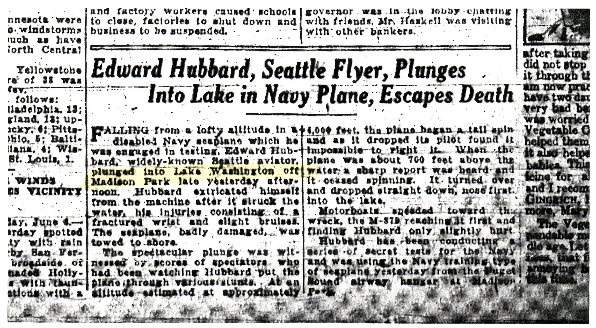
(click to enlarge)
Noted comment within article: “The seaplane, badly damaged, was towed to shore.”
It is unlikely any substantial portion of this aircraft remains in the lake. But I would expect that as a result of crashing nose first into the water at a high rate of speed (from a fall that originated at 4000 ft) at least some of the wreckage remains in the lake.
Date: 6/5/1925
Type: Boeing Model 21 (NB-2)
Common Name: Boeing Biplane Seaplane Trainer
Serial/BU#: A-6788
Sqd/Group: US Navy
Pilot: Hubbard, Ed
Rank: Civilian
Injuries: Minor
Remarks: Engine Failed
Recovered: No Information/Unknown
Other Remarks:
“plunged into Lake Washington off Madison Park”
“crashed nose first at high rate of speed”
“[took off from] Puget Sound airway hanger at Madison Park”
General Info:
As Boeing became recognized as the leading designer of military aircraft, it received in 1923 a Navy order for the trainer Model 21, or NB-1 and NB-2. The company delivered 70 Model 21s in 1924 and 1925.
Variants
The NBs were produced in two batches; the first (NB-1) were powered by radial engines and the second by war-surplus V-8s still in the Navy’s inventory.
NB-1 Photos
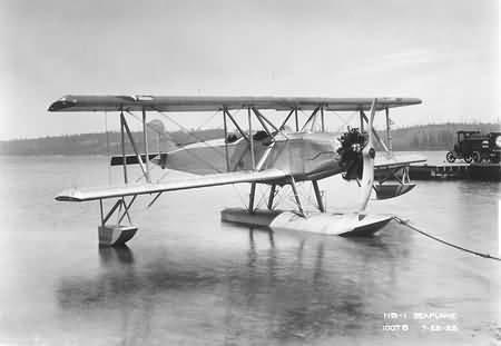
(click to enlarge)
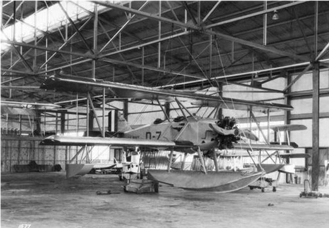
(click to enlarge)
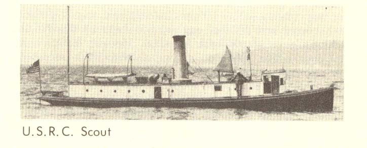
Historical Information on the USRC Scout
[Reprint of contents published by WJaccard, SCRET.org June 2008]
In 1897, a 65 foot wooden revenue cutter was built
at Port Townsend to patrol the waters of the Puget
Sound. The boat had a 9 ft. 6 in. beam and 5 ft. 5 in.
draft. She was powered with a compoundexpansion
steam engine, and her main tasks were
to deal with illegal immigration and drug smuggling.
In 1903, another wooden revenue cutter was built at
Astoria to patrol the waters off Oregon. This boat
had a similar design and similar dimensions to the
original Scout, but was reportedly only 62 ft. long.
This revenue cutter was originally powered with a
compound-expansion steam engine, and originally
named “Patrol.”
In 1915, the “Patrol” was completely rebuilt and
equipped with a three-cylinder, 50-horsepower
gasoline engine. At that time, she was renamed
“Scout” and transferred from Astoria to Puget
Sound, where she replaced the original “Scout.”
This new Scout was the fourth motor-powered craft
in Coast Guard service, exclusive of motor tenders
used by the large cutters. She was commanded by
Pilot Benjamin Lichtenberg.
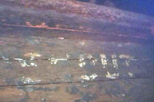
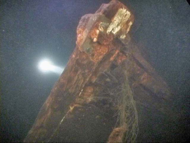
The remains of one of these revenue cutters named
“Scout” are located in Lake Washington, off Yarrow
Point, in approximately 85 feet of water. The
wooden hull rests on its port side. The hull is intact
but empty. The name “Scout” is still legible on the
sides of the hull near the bow. It appears that the
vessel was stripped and then the hull was scuttled.
While we have measured the dimensions of the hull
in the lake, given the similar dimensions of the two
revenue cutters and uncertainty as to how the reported
measurements were taken, we cannot determine
with any certainty which “Scout” is in the lake.
The Andelana was a British bark that vanished during a Jan. 6, 1899, windstorm while moored in Tacoma’s Commencement Bay.
[The four-masted British bark had been moored there, roughly 500 yards from shore. The crew had unloaded its cargo of steel and was bunked down for the night. The plan was to load up with wheat in a day or two and set sail for San Francisco. Without ballast, the 300-foot ship was kept on even keel by chains fastened to heavy logs on either side.
Then, during the night a windstorm hit and the ship vanished, slipping silently below the waterline and entombing all 17 sailors aboard. It had not been rammed or burned; no one saw or heard it go down. It appeared that the rigging broke during the storm, tipping and capsizing the Andelana.
The loss of life – the worst ever in the bay – and the way the Andelana simply disappeared in a protected harbor made it something of a mystery ship as years passed.] [Story Credit: Seattle Times, 2000]
It has apparently been found from time to time – In 1935, a diver looking for a tugboat’s anchor stumbled upon the silt-covered hulk of the Andelana. In 1954, some of the ship’s ironwood railing was hauled up and made into gavels for Republican clubs around the state – but the wreck has never been explored by divers.
I believe the Commencement Bay bathymetry points to its location. In the bathymetry included here the wreck is marked as ‘Target with Shadow’ and lies between 60 and 80m; which would give the depth of the wreck as approx 230ft.
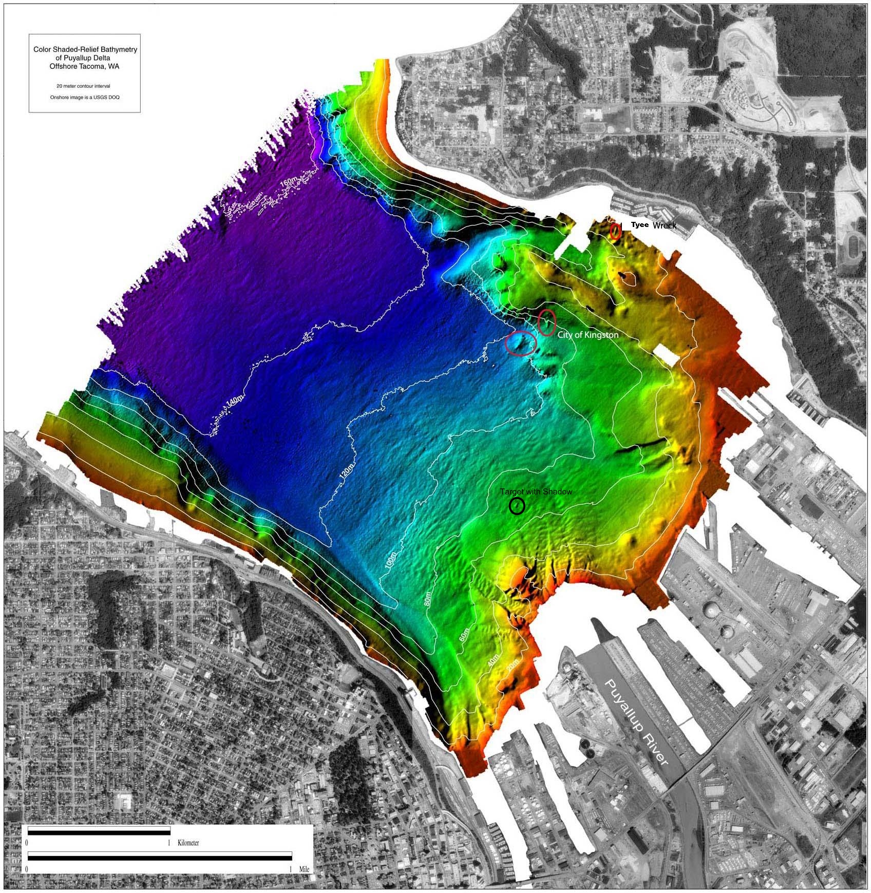
(click to enlarge)
USRC Scout
(click to enlarge)
‘Scout’ still visible
(click to enlarge)
Bow
(click to enlarge)