Underwater Photos of the SS Success

As promised, here are some UW photos of the SS Success. 
Five shots: 1 inside pilot house, 1 outside the pilot house and 1 outside the aft cabin

merge2.jpg
(click to enlarge)

Inside Pilot House
success_pilothouse_interior.JPG
(click to enlarge)

Pilot House
success_sharps_pilothouse.jpg
(click to enlarge)

Aft Cabin
success_sharps_aftcabin.jpg
(click to enlarge)

Target 3: Gas Powered Craft of the 30’s or 40’s

This past Sunday I made a dive with scret.org friends on the target previously described here as Target 3. This craft is approx 37ft long and is sitting in 200ft of water off Madison Park.

The exact identity of the wreck is unknown.  I’ve attached a side scan sonar image with this post so you can have a look – pay special note to the shadow of the sonar as it reveals quite a bit about the architecture of the boat.  You can clearly see the great condition of the wreck in the sonar image.  The entire cabin of this one is still intact. 

Prior to diving this one, and based on what we were seeing in the sonar image, I expected this wreck to be a small steam tug.  At approx 37feet long it is too small to be a passenger ferry. 

We were surprised to find on diving it that it was a gas powered craft – probably of the 30’s or 40’s. It could be that this wreck was a small work boat – or even a pleasure craft. As can be seen in the sonar image, the wreck is generally intact. The forward and aft cabins are still structurally sound, there is a small washroom sized area inside of the cabin, with its door off the hinges. A single porthole on each side gives peering opportunity into the forward hold.

There is no indication of how or why this boat sank; no sign of fire or collision. The guess is that it was intentionally scuttled as most of her equipment is gone.

I’ll post some underwater photos of this wreck, as well the SS Success, here sometime soon.

JS

Target 3 Sonar

Three new Shipwrecks of Lake Washington & Details on the SS Success:

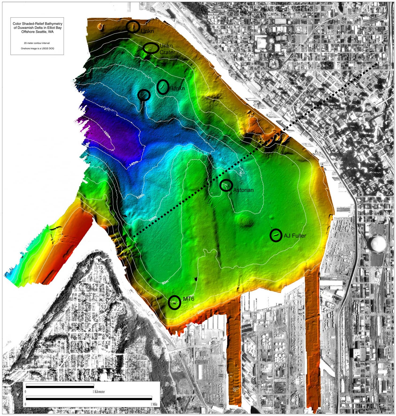
This past March, as part of research & exploration sonar work I was doing with Innerspace, we discovered three more shipwrecks in Lake Washington. All three targets are in depths ranging from 190 to 210 feet, and I expect all three targets to be of significant historical value.

Some high level details of the finds:

Target 1:  Possible River Patrol type military boat, 45 feet long, 14feet wide, 9-10feet tall.  I believe this one could be the Coast Guard picket boat which sank in 1958

Target 2:  50ft long boat, 14-16feet wide, 9ft tall.  This boat appears to have sustained heavy stern damage.  Cabin still intact.

Target 3:  approx 40ft long boat, 8ft tall.   Appears to be a fully intact (including boiler and stack) cabin-forward passenger steamer. 

I’ll discuss Target # 1 and Target # 3 at a later date, but for this post:

Target # 2
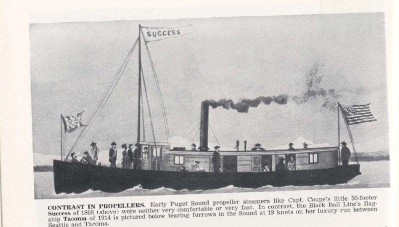
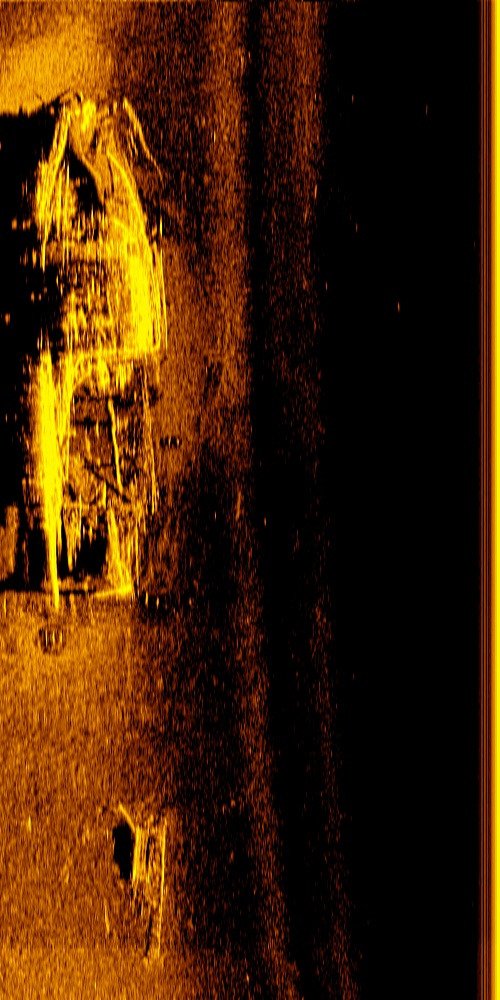
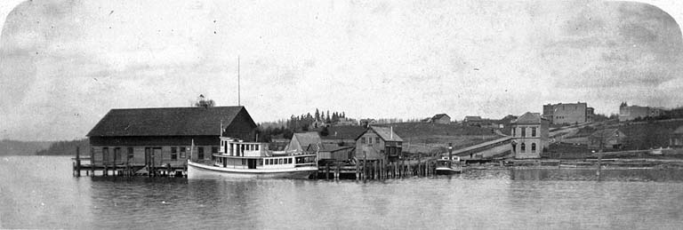
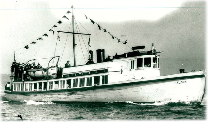
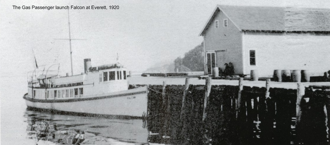
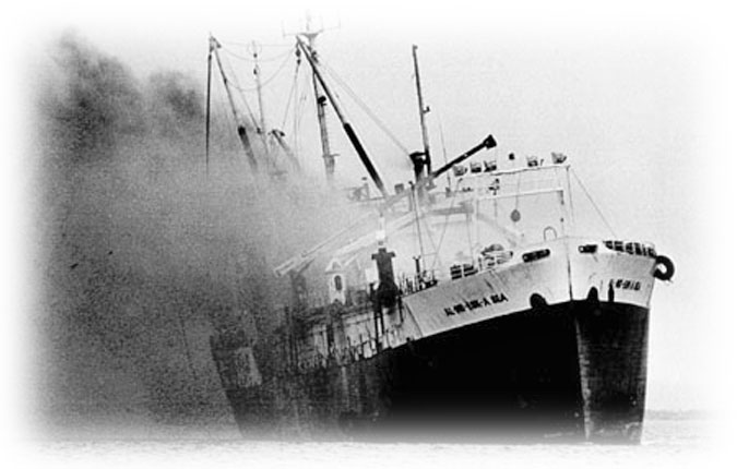
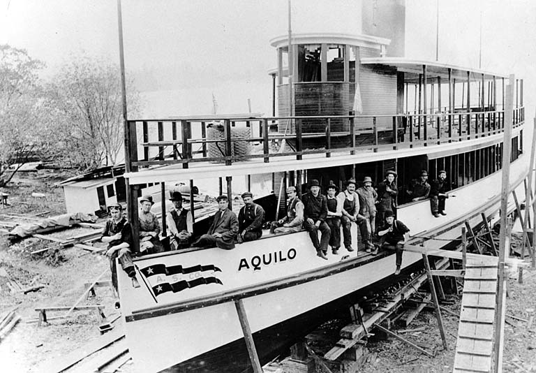
From reports of its sinking (general location), as well it’s dimensions & architecture, I believe Target # 2 is the remains of the SS Success.

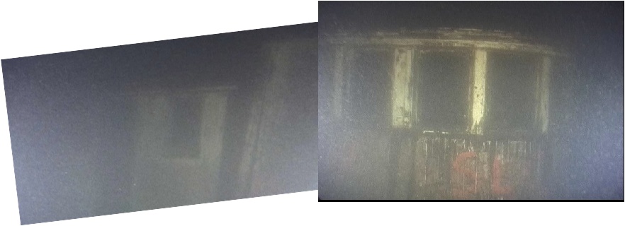
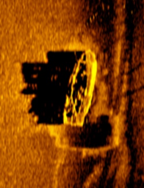
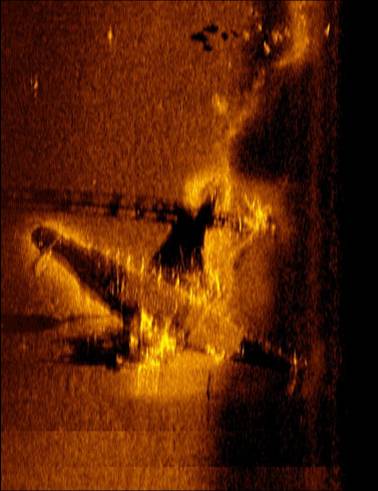
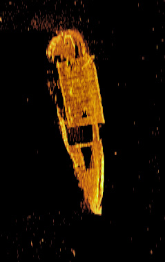
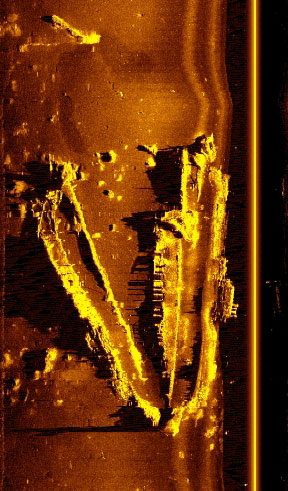
The sonar for Target #2 is included below. While the image I include here does not capture the target’s shadow – which often reveals the most about a target – what you can clearly see with this image is that the stern is badly damaged, the wreck has cabin structure and it appears in the sonar that the front of the cabin is somewhat rounded. The wave in the image at the bow is caused by just that: a wave on the surface as we were scanning the target.

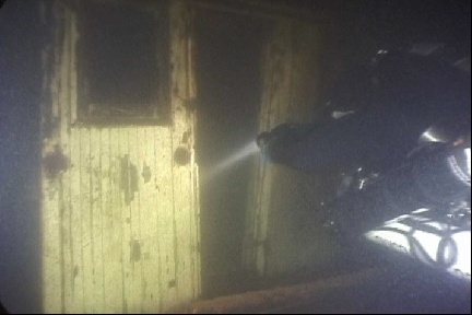
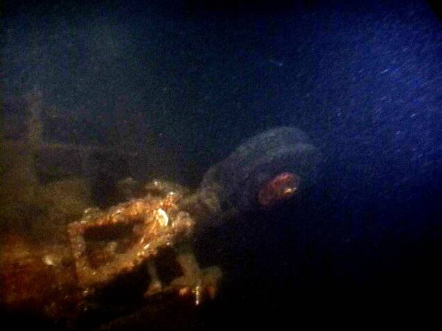
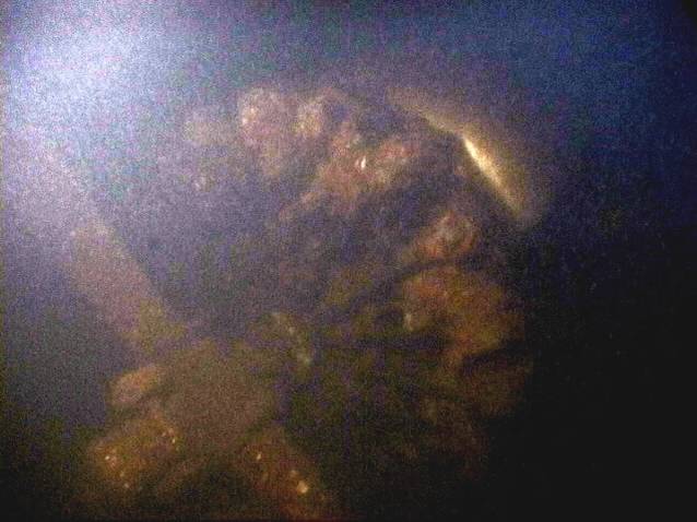
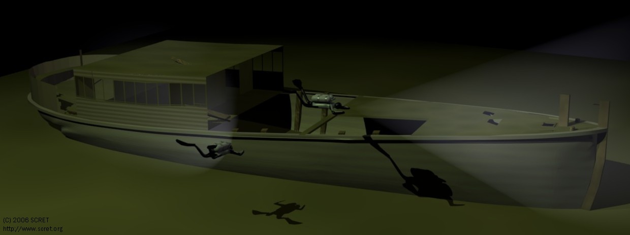
We made dives on Target # 2 this past Sunday. She is sitting in 195ft of water, bottom temp was a cool 44 degrees and visibility was surprisingly poor for this time of year. That said, we were still able to get good video of this wreck and we’ll make it available for viewing at 5th Dimension.

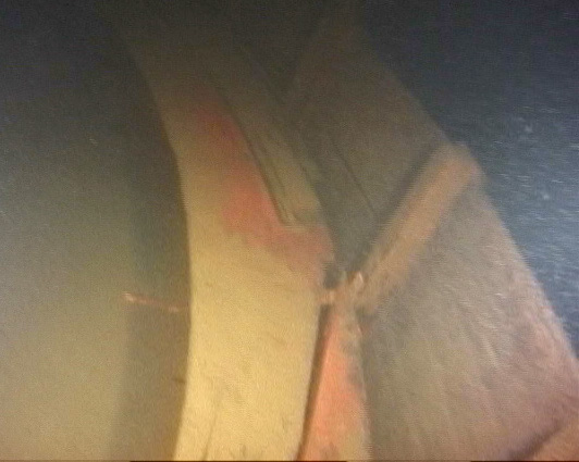
As is obvious from the sonar image, a significant portion of the stern has sustained heavy damage. Though from the dive, and later reviewing the video, there is no indication this damage was caused by fire or even collision. Instead it appears the wreck sank stern first and broke apart on impact with the bottom of the lake.

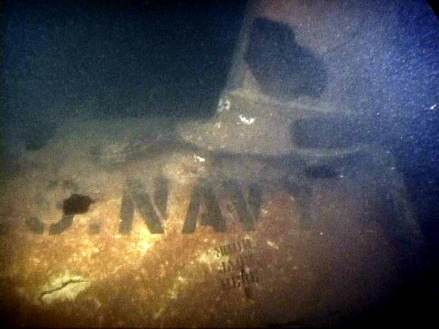
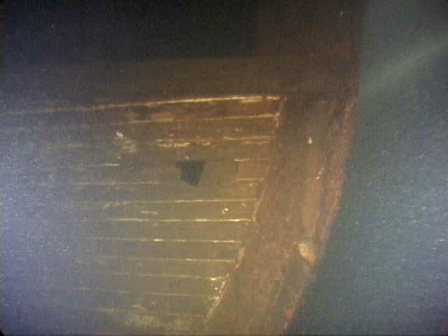
The round nosed pilot house, the stepped cabin roof and the first room behind the pilot house are the remaining undamaged portions of the Success. The space behind the pilot house still contains a bunk – the room likely serving as sleeping quarters for the Pilot and/or crew.

success.jpg
(click to enlarge)

target2.jpg
(click to enlarge)

Lake Washington Passenger Steamer: Elfin

I made a dive on the Elfin today along with scret.org friends. 

The Elfin was built in Pontiac in 1891 as a replacement boat for captain Frank Curtis who had lost the Squak on Christmas Day, 1890.  Curtis commissioned E.F. Lee to build the steamer. 

4th of July, 1891 the Elfin began making round trips from Northrup’s Landing (present day Yarrow Bay) to Kirkland and Houghton, then across the lake to Madison Street.  The Elfin made 6 of these trips per day and a one way fare was just 10 cents. 

In 1896 the Elfin was rebuilt; the pilot house being moved to the upper deck to yield greater passenger capacity and the 54.5 ft craft was also outfitted with a new steeple-compound engine.

In 1900 the Elfin was destroyed by fire.  The engine was the only item salvaged and it was later incorporated into another small passenger steamer named Peerless, built by Captain Curtis and his sons who by this time had gone into the ship business for themselves.   The Elfin’s engine then ran in the Peerless for a few years on the Black River for the Everett-Cooperville run on Puget Sound.

Today the Elfin rests on a gentle slope off Houghton in about 140ft of water – the top of the wreck up near 125ft.  It is an empty burned hull that is sitting upright and there is a 2.5 foot rim of decking still around the outside edge up near the bow and back at the stern.  Some of the white paint that made up the top half of the hull, and some of the dark paint used on the bottom portion of the hull, is still visible between the timber joints.  Those timbers that were below the fireline are generally in good shape; and there are a couple short pieces of wood framing jutting upwards near the location of the pilot house.

We circled the wreck from the outside two full times, then dropped inside the hull and swam the length of the steamer down and back.

A second group of divers was planning to dive the wreck after us, and they were planning to shoot video.  If they post the video I will grab some stills for the page here, otherwise you can reference scret.org for underwater images taken from 2002.  

 elfin.jpg 


SNV-2 Valiant

I made a dive on a Vultee SNV-2 Valiant aircraft on Sunday. This is one of Lake Washington’s little known aircraft wrecks. The Valiant was a basic trainer during WWII. There were some 11,000 produced between September 1939 and August 1944 to meet the training needs of the Army/Navy.

Valiant Vital Stats:
Manufacturer: Vultee
Designation: SNV-2 Valiant
Aircraft Type: Trainer
Wing Span: 42ft, 2in
Height:12ft, 5in
Length: 28ft, 9in
Top Speed: 166mph
Range: 516 miles
Empty Weight: 4360 pounds
Crew: Student pilot and instructor
Service Ceiling: 16,500ft
Engine(s): one 450 hp Pratt & Whitney R-985 Junior Wasp radial engine

The story on this particular wreck was that the pilot came in high on an emergency landing due to engine trouble. He overshot the runway then attempted to come around again when the engine cut out entirely. This forced a water landing which ultimately left the Valiant where it remains today (60+ years later): 130ft below the surface of Lake Washington.

The wreck lies horizontally on the bottom and it is extremely fragile. As supplies of strategic metals became prioritized during WWII, later models of the SNV incorporated wooden structural elements, including plywood panel skins. This aircraft was one of those later models and the underwater environment has not been kind. It’s BF Goodwrench tires jut upwards from the fuselage, the bent propeller and engine sit nicely out in front, and the gem of the wreck, the data case, is resting just inside the torn and jagged fuselage, still clearly marked, ‘DATA CASE.’ On the wings the White Navy star is visible as well as the, ‘US NAVY’ lettering.

Included with this post are some underwater photos and a sidescan sonar image.

JS

picture1.jpg

picture4.jpg
(click to enlarge)

picture3.jpg
(click to enlarge)

picture2.jpg
(click to enlarge)

Sunken Concrete Pontoon

In July we dove a new target; one I am not sure anyone has dove before.  It is a huge concrete structure at the south end of Lake Washington – we came across this structure while doing some side scan sonar work in the area.  It is approximately 200 feet long and maybe just 20 feet wide.  In all it took us about 35 minutes to swim around the entire thing.  It appears to have massive holds inside; leading us to believe this space was used for ballast and this structure is either an old floating pier or it was at one time a section of the original floating I-90 bridge.

Falcon: Underwater Images

Here are some  underwater images from the Falcon dive.  Dark grainy photos but those are the conditions we deal with 200 feet below the surface. 

falcon_cabin_windows.jpg
(click to enlarge)

falcon_bow-3.jpg
(click to enlarge)

falcon_bench_seats.jpg
(click to enlarge)

Falcon

After a long break between wreck dives I was back in the water again on Saturday with scret.org friends.  

This time we were out in Lake Washington and diving the ‘Falcon’ – an early 1900’s passenger steamer that sunk in Lake Washington under unknown circumstances.  The Falcon was built in Bellingham in 1908 and used by the Island Transportation Company for service between Bellingham and Anacortes. The Falcon was sold to the Kitsap County Transportation Company in 1913 and later retired from KCTC’s service in 1919.  

How the Falcon made it to Lake Washington is unknown.  It is likely that after 1919 it was transferred to Lake Washington as part of Captain John Anderson’s passenger ferry fleet.  Around 1920 Captain Anderson (of Anderson’s Shipyard) was named superintendent of ferries by the county – he had been operating a number of passenger steamers on the lake for nearly 20 years (and would continue to do so as the I-90 Bridge was not completed until 1940).

The Falcon now sits upright on the bottom of the lake in 200 feet of water, north of Hwy 520’s floating bridge.  It is in fairly good shape, though the wheel house is missing from the structure.  This may indicate the Falcon was stripped then scuttled intentionally.  The square windows of the Falcon are still framed in nicely and the bow & stern are both intact. 

I’ve included a few photos with this entry: the first couple are the Falcon above water, the third is a 3D rendering of the Falcon today (forward cabin & pilot house missing) and the fourth is a sidescan sonar image of the wreck sitting on the bottom of the lake.  Sidescan imagery courtesy of Innerspace Exploration. 

falcon_main.jpg
(click to enlarge)

falcon.jpg
(click to enlarge)

falcon-original.jpg
(click to enlarge)

falcon3edit.jpg
(click to enlarge)

Multi-Beam Imaging of Elliot Bay

After the February 2001 earthquake in Seattle, NOAA and the USGS teamed up in a project to map the underwater geology of the Duwamish River delta (Elliot Bay, Seattle), the Puyallup River Delta (Commencement Bay, Tacoma) and the Nisqually River delta.  The multi-beam images they created are really interesting. 

The one I will attach with this entry is of Elliot Bay, but I modified the file a bit to highlight points of interest:

The dotted line across the image is the major fault line that runs under the bay and then up through downtown Seattle.  The sharp ridges you see on the west side of the dotted line are very pronounced faults – I have seen them with my own eyes on prior dives in this area.  But until this image was created I had never known where they connected on the other side of the bay.  Turns out they line up pretty well with Pike and Pine streets in downtown Seattle.  When the ‘big one’ happens, it is going to be devastating. 

Two of the circles on the north end of the image highlight some pretty big shipwrecks, both of which are in more than 300 feet of water.  Date of sinking, names of the ships, etc all unknown.  I’ve also circled a crater which looks very large.  It seems it was likely caused by a significant amount of ordinance – maybe during WWII.  I also circled in the NW corder of the bay what appears to be an unexplored wreck in shallow water.

The circles on the south end of the image are of three wrecks I have written about on this website, the MT6, the AJ Fuller & the Astorian.

elliot-bay-bathymetry_with_wrecks.jpg
(click to enlarge)

Back in the water

I was back in the water last Sunday after a long break.  I made a scooter run at Alki with friends.  It was a typical training dive for us; what we do in between the ‘big’ dives.  
We traveled out about 3000 feet with the average depth a bit more than 100ft and a total run time of about an hour (with deco). Pretty short dive.  Along the way we made deco bottle drops for ourselves and the team behind us that was planning to push quite a bit further.  We also made a stage drop for them at the 3000 mark before heading home.    
On the way back we ran an ‘out of air’ drill – which involves donating your breathing gas to your buddy, switching to your back-up, stowing your scooter and then getting into a tow position so the two divers can situate themselves as one long diver inline behind one scooter.  We also ran some valve drills while in the shallows just before deco.  
All in all a good refresher dive.

AJ Fuller – Redux

Made another dive on the AJ Fuller today – but this one ended up being a pretty short event. 
There were four divers including myself and we were broken into two teams.  We descended to the bottom in about 3 minutes, but this time the shot ball from our descent line was sitting on the wreck, so our bottom depth was 220ft.    

The first team had already tied in a reel to the line and were out in front of us by a couple minutes.  My partner and I were running parallel to each other and on opposite sides of their line.  We made our way from the center of the ship to the outside beam.    

On reaching the outside beam of the Fuller, I looked over to see my partner’s scooter doing its best to drag him over the edge of the ship.  Its main compartment seal had failed and the scooter was completely flooded – this made the scooter weigh a good 50lbs.  Having a 50 pound negative weight attached to you isn’t a great way to make your way around at 220ft, so we thumbed the dive and headed for home.  Just before our ascent my buddy unclipped his scooter and tied it in to our up line so as not to have to deal with the negative weight.     
By the 25 minute mark we were back at the surface for a dive that normally has a run time closer to 90minutes.  The visibility was so bad on the bottom the other team, one of which was shooting video, called their dive short as well.    

With the total amount of gear we take along for a dive like this, there are lots of opportunities for problems.  So when things do go wrong we just learn to deal with it.  The AJ Fuller isn’t going anywhere soon, so the only thing you can do is take it in stride. 

JS   


AJ Fuller

I made a dive on the AJ Fuller with SCRET.org today. The Fuller is a massive 229 foot long, three mast sailing ship that sunk in 1918.  The AJ was owned primarily by Flint & Company of New York, and named for a shareholder who lived in Bath, Maine.   The three-skysail yard ship was one of a dozen ‘Down Easters’ built in 1881. Under the Flint house flag she sailed between New York, San Francisco, and Liverpool for ten years. 

In 1892, she was put in trade from East Coast ports, where she loaded case oil for the ‘Orient’ or general cargo or coal to Hawaii, generally returning with sugar cane.  It was while she was in that trade that Felix Riesenberg, who later became a master mariner in his own right, sailed in her before the mast.

She was sold to the California Shipping Company in 1902 and used in trade between the Pacific Northwest and Australia, exporting lumber and importing coal. In 1912, she was purchased by the Northwestern Fisheries Company of San Francisco, who employed her in their seasonal salmon fisheries—sailing north in the spring with fishermen, cannery workers, and supplies, and returning in the fall with a full load of canned salmon.

On October 18, 1918, while inward bound to Seattle in a heavy fog, she was rammed by the Japanese steamship Mexico Maru and sank in about 240 feet of water.

I was on a team of three divers and there was one other team of two.  Our team was first in the water, which meant once on the bottom it was our job to locate the wreck.  We thought we dropped the anchor ball and buoy line right on top of the wreck – or we at least hoped that was the case. The visibility was incredibly great on the way down.  I really thought there was a chance we would encounter the same viz on the bottom, but we weren’t so lucky.  Around 170 feet it clouded up pretty badly and stayed that way the rest of the way down.  Since the wreck rises about 20 feet off the bottom, we expected to encounter the Fuller on our decent at a depth of about 220ft.  But we went right past 220ft and found ourselves hovering above the Puget Sound’s floor in 248 feet of water.  That is the deepest I have ever been.

We tied in a cave reel to the anchor ball and buoy line and set off looking for the Fuller.  With only 2-3 feet of visibility it took us 5 minutes to find a wreck that was really within 20ft of where our anchor ball hit the ocean floor.  Once on the wreck we encountered plenty of life.  Lots and lots of big shrimp – some big lingcod too that startled off so quickly they made the already bad visibility worse.  We were on scooters, with the lead diver running our cave line and the other diver shooting video.  I was in the number two position making sure the diver running cave line didn’t encounter any problems with that line.  Cave line has a way of being evil at depth.  We passed over China plates and tea cups, errant old bottles etc., but since this wreck is one of only two wrecks on the list of Washington’s historical sites we left what we saw undisturbed.  

At 20 minutes into the dive we ran out of line on the cave reel.  That meant we had covered around 400feet.  We cut the line and I tied it off.  Then we stayed on the scooter triggers back to our up line.  We started the ascent at 25 minutes. 

Decompression was uneventful, though long.  It took around 65 minutes to step our way back to the surface.

The Fresno

Weekend following the Al-Ind-Dusk-A-Sea dive we were back in Lake Washington for a dive on the whaling ship Fresno. 

The black/white photo included below is of the Fresno on fire in Meydenbauer Bay on April 4th, 1923.  At the time, three other whaling boats were pulled safely away from the dock and away from the burning ship after the ferry boat Leschi was unable to pull the Fresno free.  Eventually a tug succeeded in towing her out to the middle of the lake but the ship was allowed to burn as no equipment was available to extinguish the flames.  The photo is from the Collections of the Eastside Heritage Center. 

Once the flames burned themselves out the Fresno was deemed a total loss.   They filled the ship with rock and sunk her in Meydenbauer Bay where she now sits on the bottom, 180 feet below the surface.  Also included below is a sidescan sonar image of what the Fresno looks like today.  The hull of the vessel is broken apart right along the spine and rests into two distinct pieces connected at the stern.  I suspect she sunk to the bottom stern first then broke apart on impact – and that is why we see separation between the hull structures.  The rudder of the ship appears as a long thin shadow in the side scan image.  Also visible in this image are the remains of the rigging (about half way down the hull on the starboard side – the section in the top half of the photo). 

For our dive on the Fresno we dove as one team of three and one team of two.  Visibility in the shallow depths was great, which meant the very limited visibility we encountered on the bottom was expected.  We had to tie a reel into our anchor line and run cave line while touring the ship.  Running the cave line was the only way to ensure we could get back to that anchor line, our “up” line, in the limited visibility. 

We planned for a long bottom time, so we carried stage gas in an 80 cu ft tank in addition to the double 104 cu ft tanks on our back and the two 40cu ft deco bottles of 50% and 100% oxygen.  We used 18/45 (oxygen/helium %) for our stage and back gas.   

After a cold 30 minutes on the bottom we headed for home which meant another 60 minutes in decompression back to the surface.

fresno1.jpg
(click to enlarge)

fresno__sonar.jpg

Al-Ind-Esk-A-Sea

Our dive on the Al-Ind-Esk-A-Sea, or “Big Al” as we like to call her, is complete.

With a history that includes everything from being a Cruise Ship, a US Navy Ship and a private yacht, the Al-Ind-Esk-Sea floated her last days as a fish processing ship – owned by TransAlaska Fisheries Corp.  You’ll read in the scret.org link that she was capable of processing and carrying more than 5 million pounds of packaged seafood in her refrigerated holds.  This freighter has a beam of 50 feet and is more than 300 feet long.

In 1982, 23 years ago this month, Big Al was at anchor in Port Garner undergoing repairs when a fire started on the ship. Due to the 18 tons of ammonia on board (used in the ships refrigeration system), fire fighting crews stayed away from her.  She burned for two days and then rolled on her side and sank to the bottom of the bay.  She now rests on her starboard side, 240 feet below the surface, just a half mile off shore.       

Our dive operation on Sunday consisted of two teams of 3 divers each, 2 safety divers and our captain Troy of Porthole Dive Charters.  I was on the first team of divers, and after hooking the wreck while above water, our first goal for the dive was to free the grappling hook, then carry it to the top and set on the port side of the wreck.  Completion of this task would enable us to retrieve the grappling hook at the conclusion of the dive – once everyone was back on board.  Once the grappling hook was sitting on the top of the wreck and free of obstruction, we planned to explore the wreck using our Gavin scooters then terminate the dive at a run time of 20 or 25 minutes.  

The first task turned out to be a pretty hairy experience: we found the grappling hook on the bottom, near the 240ft mark, and it was stuck in the mud.  The hook weighs more than 20 pounds and the only way to get it out of the mud was to grab hold of it and inflate the buoyancy control wing just enough to pull it free.  My friend took on this task and on the release of the hook from the mud two expected things happened: 1) a cloud of slit significantly reduced visibility and 2) the inflated wing pulled him rapidly upwards about 10-20feet.  In this process something unexpected happened.  All three of us rose up underneath an almost invisible spider web of old fishing line.  It was an unnerving 5 minute process, sitting at a depth of about 220 feet, to cut ourselves free of this underwater killer, and if we hadn’t kept focused it might have meant death for anyone of us.     

After the fishing line incident, we all signaled that we were still ok and with 15 minutes of bottom gas left to burn we set out on the scooters.  We followed the port side walkway railing from mid ship to the bow.  Riding just off this railing would have made for a photo like you would expect to see on a National Geographic video of the Titanic.  At the bow we encountered the enormous eyelet that housed the anchor chain and the big spools that had anchor chain wound around them.  We then circled back towards the mid section, taking our time looking at the deck of the ship which loomed like a 50 foot wall on our right.  Eventually we made it back towards the stern and the super structure of the ship, moved again to the top and finally back to our grappling hook sitting free and clear on top.  Bottom time was reading 20 minutes at that point, so we circled OK, gave the thumbs up sign and began our slow 60 minute decompression ascent back to the surface.    

For the dive we used a bottom mix of 15% oxygen, 60% helium and then 50% oxygen and pure O2 for decompression.   

big-al.jpg
(click to enlarge)

‘Potential New Wreck’ now named Triton or Aquilo

Have this narrowed down now to the Triton or the Aquilo.  Both were Lake Washington steamers of the early 1900’s.  There is a team of JaWS divers planning to make a dive on the wreck here in the next couple weeks.  Their objective will be to measure length, beam and draw so we can try and finalize which wreck we’re diving. 

Aquilo Launch
launching-of-aquilo.jpg
(click to enlarge)

Aquilo under Construction
aquilo-under-construction.jpg
(click to enlarge)

Triton at Dock
triton-at-dock.jpg
(click to enlarge)

Aquilo on Lake
aquilo-on-lake-wa.jpg
(click to enlarge)