
If you look at the post I have titled “Olympic Coast Shipwrecks” you’ll find a map that was put into distribution by NOAA and the OCNMS. In this map they mark the location of the SS Pacific. This position has long been understood as approximate because the SS Pacific has never been found.
I’ve been actively researching the location of the Pacific for a number of years. I now believe I know where the Pacific is located, but the environment where it rests is so harsh that even the best sonar operator in the world would have a tough time locating her – even if they were provided the exact coordinates of the wreck.
As skilled as I know the JaWS resources to be, I suspect this wreck may be impossible to locate. So rather than sit on this compiled data the rest of my life I am putting a high level overview of my research up for public consumption:
Overview:
SS Pacific (side-wheeler)
876 tons
225 feet long
30 ft width
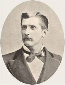
Captain: Jefferson D. Howell
Collided with square-rigger Orpheus (Captain: Sawyer) on Nov. 4th, 1875 off the coast of Cape Flattery, Washington
SS Pacific
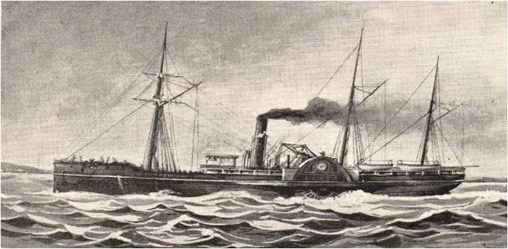
(click to enlarge)
Capt Howell & Capt Sawyer
(click to enlarge)
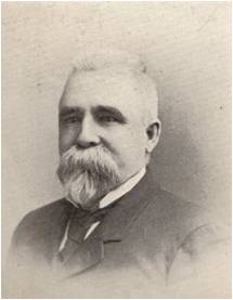
Piece of wreckage, signed: “S.P. Moody. All is Lost.”
(click to enlarge)
Cargo & Gold:
Original Print Article from 1875 reporting Cargo/Gold:
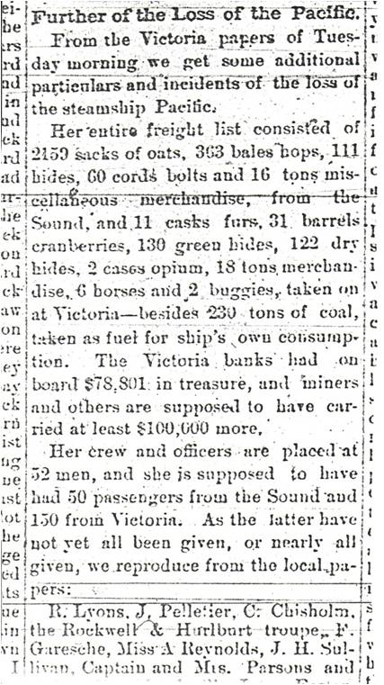
(click to enlarge)
“Victoria banks had on board $78,801 in treasure, and miners and others are supposed to have carried at least $100,000 more”
“The Pacific’s safe, a Wells Fargo shipment of $79,220 in currency and gold.”
Most estimates of this treasure conclude it is equal to about 48,000 troy ounces of gold. At current gold prices of $900/ounce we’re talking about $43,200,000 million in gold. Interested?
Other Cargo:
– 2159 sacks of oats
– 363 bales hops
– 111 hides
– 60 cords bolts
– 16 tons misc merchandise
– 11 casks furs
– 31 barrels cranberries
– 130 green hides
– 122 dry hides
– 2 cases opium
– 18 tons merchandise
– 6 horses
– 2 buggies
Mapping Location:
Here is the high level process I went through in estimating the Pacific’s location:
Current Navigational Route Marked in Black
(San Diego to Strait of Juan de Fuca) :
Closely follows 3 nm contour:
46 11′ N, 124 12′ W (off Columbia River)
48 10′ N, 124 52′ W (off Umatilla Reef)
48 26′ N, 124 47′ W (off Cape Flattery)
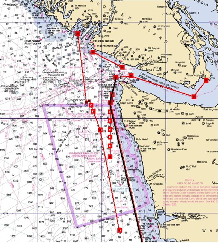
(click to enlarge)
Sworn Testimony: Capt Sawyer of Orpheus (As Reported by Victoria Colonist, reprinted by Seattle Star, Nov 1875):
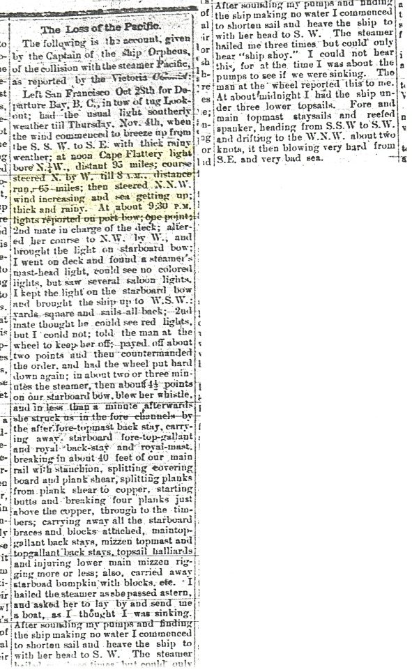
(click to enlarge)
“[…] at noon Cape Flattery light bore N.1/4W., distant 95 miles; course steered N. by W. till 8 P.M, distance run 65 miles [65/8=8 knots]; then steered N.N.W. wind increasing and sea getting up; thick and rainy. At about 9.30 PM lights reported on port bow; one point.”
N.1/4W = 357.18 degrees
N. By W = 348.75 degrees
N.N.W = 337.5 degrees
1 point = 11.25 degrees
Capt Sawyer/Orpheus Route , San Fran to Departure Bay, BC (based on sworn testimony):
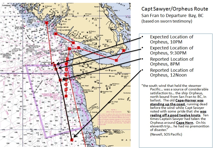
(click to enlarge)
Expected Route, SS Pacific (Victoria to Tatoosh):
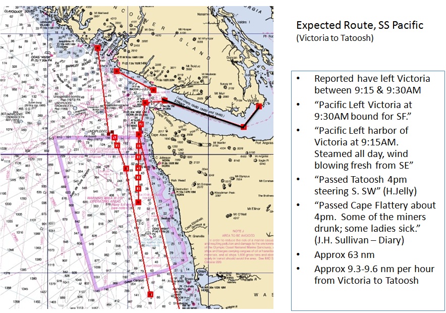
(click to enlarge)
Expected Route, SS Pacific (Tatoosh to San Fran):
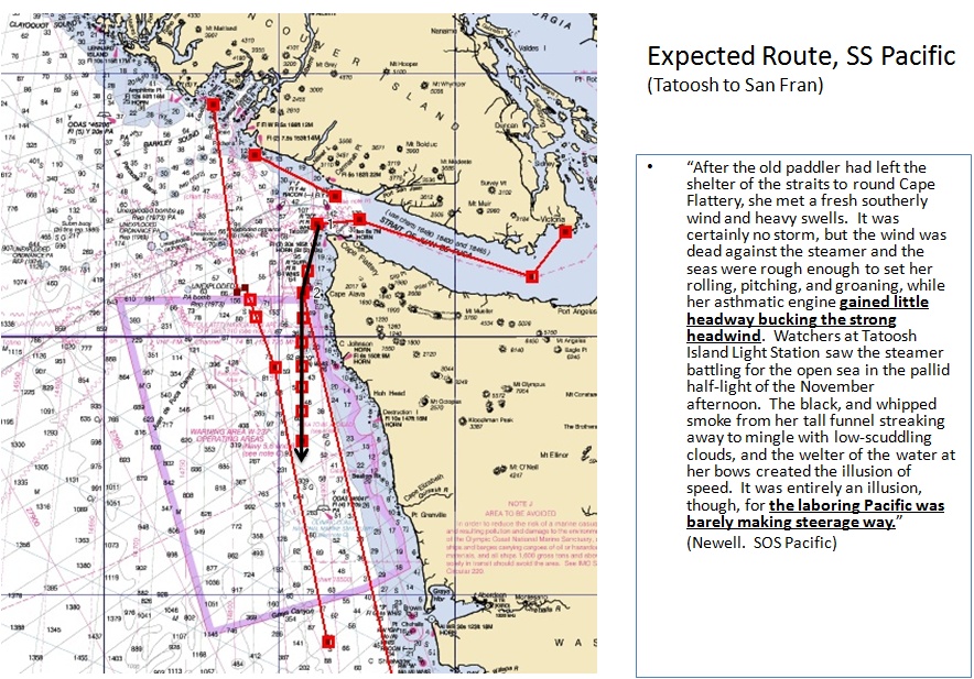
(click to enlarge)
SS Pacific Route (Variable Speeds from Tatoosh):
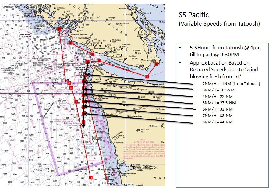
(click to enlarge)
Orpheus / SS Pacific (Convergence Area):
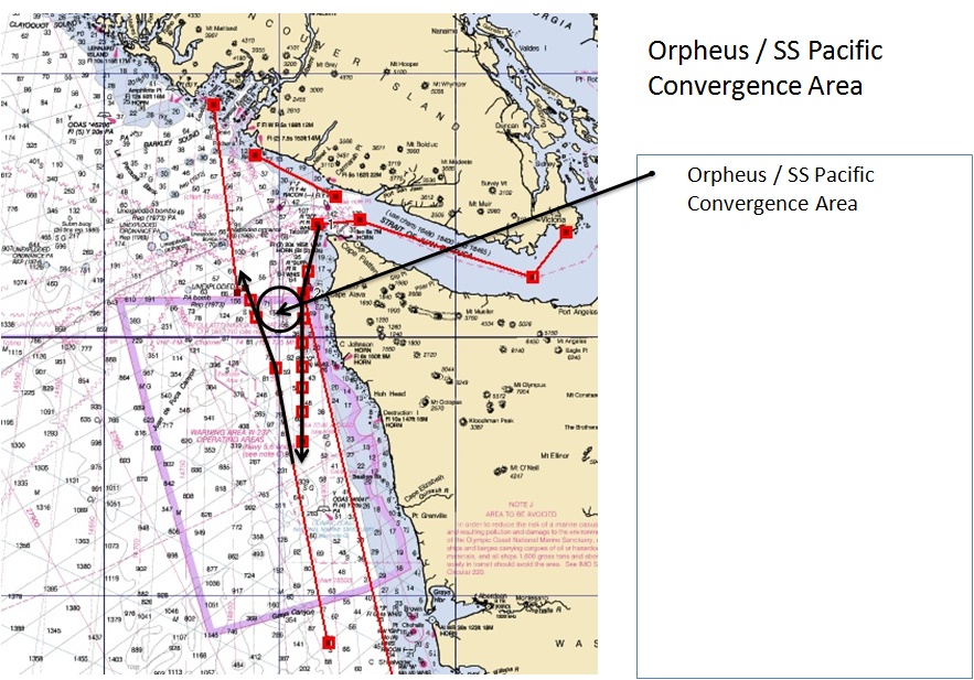
(click to enlarge)
Area of High Probability:
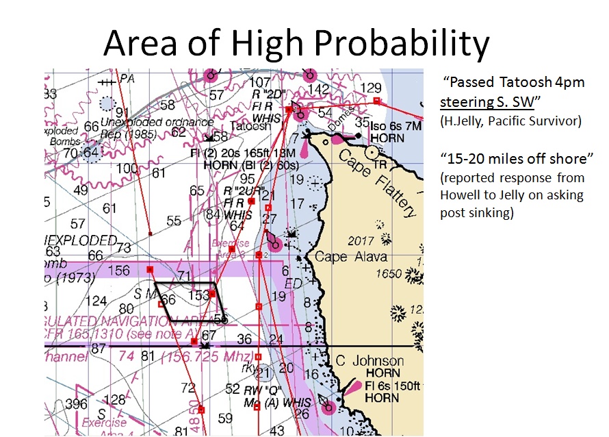
(click to enlarge)
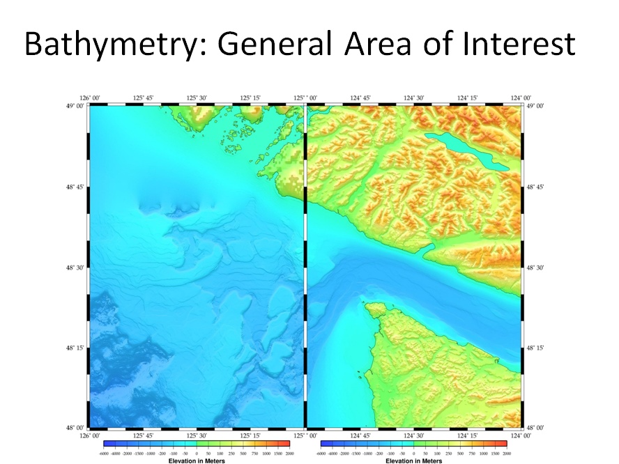
Bathymetry: General Area of Interest
Area of High Probability (with Bathy overlay):

(click to enlarge)
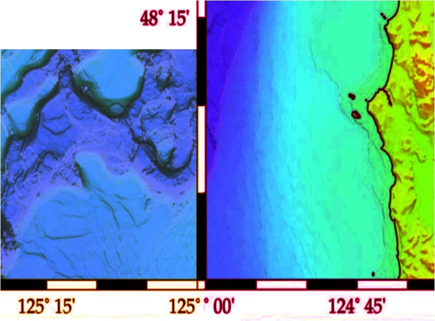
Final Close-Up of Expected Location (Juan de Fuca Canyon):
(click to enlarge)
So far as I have been able to put together, the players that are or have been involved in looking for the Pacific are as follows:
– JaWS Marine
– Odyssey Marine (note “Seattle Project” within the “shipwrecks” section of their website)
– Pacific Sea Resources (William M Mathers), who contracted a search with Oceaneering.
– Jeff Hummel
Interestingly, there is a bit of a web that ties a lot of them together:
Jeff Hummel is locally known for pulling a Corsair out of Lake Washington in 1984 and then fighting the US Navy for ownership, and winning. He is or has in the past been partnered with Bill Mathers and is reportedly required to make a yearly expedition to look for the Pacific or risk breaking one of his contractual agreements. Jeff’s current claim is that he has located a piece of coal that he had analyzed by an expert who told him it was coal from a mine near Coos Bay, Oregon. Which if true would be significant because the Pacific took on coal in Coos Bay. But while it seems possible an expert could date the coal, it seems highly unlikely an expert could tell what particular mine a piece of (130+ year old/brought-from-the-ocean-depths) coal was extracted from.
Bill Mathers of Pacific Sea Resources holds the strongest position in my opinion as he had the foresight many years ago to pre-arrange exclusive ownership agreements with the US Salvage Association, Fireman’s Fund and the American Presidents Lines. These three companies are generally accepted as the companies who could lay insurance claim to any treasure that was recovered from the Pacific.
Because of Bill’s arrangement with those organizations, Odyssey Marine negotiated an exclusive agreement with Bill Mathers. Note Odyssey’s quote on the subject: “Odyssey has reached an agreement with researchers and insurance interests that gives the company 80% of any net revenue generated by the project.” This likely means if Odyssey located the wreck they would get 80%, Bill Mathers would get 10% and the insurance interests would get the remaining 10%.
JaWS actively tried to strike an agreement with Bill Mathers as well but despite numerous discussions with Bill over the course of last year, Mr. Mathers remains unwilling to depart from the behemoth Odyssey Marine. Though I believe quite strongly Odyssey will never be back to search for the Pacific.
Why won’t Odyssey go back? Is the possibility of $40-$50 million in treasure and not having to deal with any courts other than our own not enough to allure them back? Further, why hasn’t anyone else been successful in locating the Pacific despite numerous attempts?
Look again at the bathymetry image:
My research would indicate the SS Pacific is sitting somewhere in or around that Juan de Fuca canyon, a canyon that drops quickly from 71 fathoms (426ft) to 153 fathoms (918ft). That is one hell of a steep drop in an environment of house sized boulders and high currents.
I think Odyssey has determined the wreck to be in the same location and hit the area (and surrounding area) very hard in 2003. When identified targets outside the canyon proved dead-ends, they came back to the conclusion that the wreck lies in the canyon and scrapped their plans to come back in 2004 or beyond.
Operations smaller than Odyssey (i.e. JaWS, Mathers, Hummel) may still mount expeditions to try and locate the wreck, but to be successful a very skilled crew and sonar operator are going to have to run the capital equipment risk of doing very low flybys through that canyon – and even if a capable crew comes together to pull it off, the sonar returns that will be banging off the side of that canyon are going to make it nearly impossible to discern the 130+yr old remains of a ship ravage by the collision, the sinking, the rocks, the depth and the relentless current.
Additional supporting documentation included in the post below.